Posts

Gopalaswamy Betta - Bangalore Travel

Image
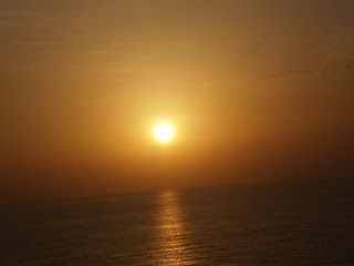
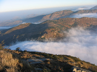
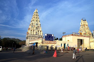
Go a Trip to Gopalaswamy Betta By Isaac Nathaniel Himavad Gopalaswamy Betta, is a hill located in the Chamarajanagar district at a height of 1450m and is extensively wooded. It is also the highest peak in the Bandipur National Park. It lies in the core area of the Bandipur National Park and is frequented by wild life including elephants. Dense fog predominates and covers the hills round the year and thus gets the prefix H imavad(in the native language of Kannada) and the temple of Venugopalaswamy (Lord Krishna) gives the full name of Himavad Gopalaswamy Betta. Read More 

Gokarna- A Serene Place to visit

Image
Travel to Gokarna, a beautiful village situated in Northern Karnataka. It lies between the two rivers Gangavali & Agnashini on the coast of Karwar. The name Gokarna is derived from the two word “Go” which means Cow & “Karna” which means “Ear.” According to mythology, Lord Shiva was born here out of a Cow’s ear and hence the name Gokarna. Gokarna was a part of Vijayanagar & Sodhe Kingdoms, before it was taken over by Portuguese. Read more at http://www.bangalorexpo.com/component/content/article/148-india/52001-gokarna-a-serene-a-pious-place-to-visit.html

Palolem- The Unexplored Beach of Goa

Image
Palolem is a beautiful beach situated at South Goa. It is located around 25 kms from Margao(the main city in South Goa) and is just 30 kms from the town of Karwar in Karnataka. Palolem beach is unknown to many and hence it is one of the cleanest and unspoiled beaches you can ever find in Goa. It is a lovely beach which is crescent- shaped. Both ends of the beach consist of rocks jutting out into the sea. The depth of the sea is shallow in the beginning and increases gradually, making it comparatively safer for the swimmers. The beach is inhabited by local fishermen and foreign tourists who lives in shacks along the shore or the main village. For more details visit http://www.bangalorexpo.com/component/content/article/148-india/48173-palolem-the-unexplored-beach-of-goa.html

St. Mary's Island

Image
Place name: St. Mary's Island Country: India Location: 58 km north of Mangalore and little to the north of the port of Malpe town Type: Beach, island About the Place: St. Mary's Islan d is a small group of islands located 58 km north of Mangalore and little to the north of the port of Malpe town. These islands are well known for their famous basalt rocks which have crystallized into columns and split into hexagonal mosaic. Malpe: This is one of the major fishing harbor in the West coast and has a fabulous view. This is located 5km West of Udupi town and which makes us surprised by its beautiful scenes and a very beautiful place to take sea bath. St. Mary's isles are group of islands accessible by ferry from Malpe. Vascoda Gama appears to have touched the island in 1498 before he reached Calicut. These islands are nothing but a few scattered projections of rock rising out the Arabian Sea around Malpe. It has a coconut garden, which makes it the shadiest isle of the group

Kaup Beach

Image
Place name: Kaup Place Type: Beach Country: India About the place Kaup Beach: Kaup is a small village located about 20 km from Udupi on the National Highway 17 towards Mangalore which is a coastal belt. This is one of the highly populated beaches in Karnataka. This beach is widely known for its peaceful and cool atmosphere. This beach is covered by greenery from all the sides. The cool breeze that blows across the white sandy Kaup beach at Karnataka refreshes you from your tiredness and tensions and gives a pleasant feel to your mind. Kaup is the perfect venue for organizing picnics with family and friends. You can also enjoy some water sports or swimming in the sea water. This is a perfect weekend spot as you can take a relaxing sun bath or stroll across the white sand. The fragrance of the surrounding flora that blows across the whole beach along with the cool breeze from the waters has got a soothing effect. Transport: Local transport can be taken from Udupi. Hotels in Kaup Be

Skanda Giri

Image
Place name: Skanda Giri Type: Hill Country: India How to get there: There are two routes to Skanda Giri: 1) Proceed directly to Kalawara village from Chikkaballapur. 2) From NH-7, turn towards Nandi Hills. At the base of Nandi Hills turn right and proceed to Kalawara village via Muddenahalli Location: 70 km from Bangalore, Chikkaballapur. It is off Bellary Road (NH-7 Hyderabad-Bangalore Highway). About the place: This is located in the Chikkaballapura district of Karnataka. The village name is called as Kandavara Halli and the hill is called as Kandavarahalli Betta Kalawarahalli Betta). This is one of the hill forts in the Nandi Hill ranges and history says that this is a small but strong hill fort. Tippu Sultan reportedly captured this fort from a local ruler by bribing two milk women who used to supply milk to the ruler to poison him and his men to death. On 19 October 1791, it was surrendered to British troops. It remained in British hands until the peace treaty of 1792, which conc

Male Mahadeshwara hills

Image
Place name: Malai Mahadeshwara hills Type: Temple Distance: 210 kilometers from Bangalore Country: India Location: Eastern parts of Kollegal Talluk, Chamarajanagar district About the place: Malai Mahadeshwara is a sacred place for Hindus located 140 km from Mysore which is about 3000 feet from the sea level. Malai Mahadeshwara is also known as MM hills which has a temple dedicated to Mahadeshawra attracting not only pilgrims but also nature lovers. Malai Mahadeshwara is surrounded by 77 hills in the Eastern Ghats. Mahadeshwara is said to be the incarnation of Lord Shiva. Thousands of devotees from Karnataka, Tamil Nadu and the neighboring states visit this place and will have a holy dip in Antaragange, near the temple, rising from the ground and whose origin is not known. In Puranas (Hindu literature), the hills of Mahadeshwara are described as Jenumale, Anumale, Pachchmale, Kanumale, Ponnachimale, Pavalamale, and Kongumal. The dense deciduous variety forest is famous for its bamboo tr